On maps, species and clima
Maps are a key tool for ecologists and naturalists. What is its origin? What applications can have? The phenomena that studies ecology have an important geographical base, depend on the space environment in which they occur. For this reason, cartographic techniques in combination with computing and large databases can help us to study, for example, the relationship between climate, human legacy and the current distribution of species.


![]()
For Luciana and Gerard.
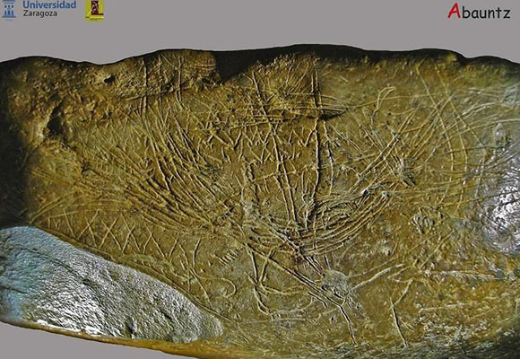
In 2009, Dra Pilar Utrillo and her team unveiled the discovery, in a cave in Navarra, Spain, of a Paleolithic stone in which a series of lines had been engraved. This stone, became the first cartographic representation made by humans (Figure 1). It is an illustration of mountains, rivers and fords reasonably useful for hunting parties. The meaning of this curious stone is more akin to ecologists - to site the location of resources in a natural environment - than to the medieval charts, whose main purpose was to guide travelers and ultimately define areas of political or commercial influence.
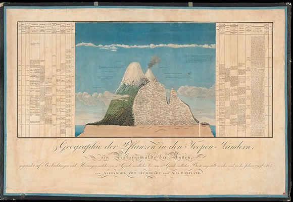
The detailed cartography of the orography, coasts and bodies of water, as well as the communication routes, reached its fullness in the 19th and 20th centuries. At that time, cartography developed as an essential tool for war and territorial domain, as recognized by the great geographer Yves Lacoste. For their part, naturalists soon used the maps to describe large units of vegetation and to interpret them. Alexander von Humboldt published in his Geographie der Pflanzen, in 1807, an iconic diagram - Naturgemälde - showing the distribution of vegetation on the slopes of the Chimborazo volcano, which is considered the first ecological description of the vegetal landscape (Figure 2). Since the nineteenth century, botany and zoology have been interpreting the distribution of species in the territory, developing the discipline of chorology. To do this, cartographies showed the places where the specimens were found, and then they were interpreted, giving particular relevance to historical and evolutionary processes. Biogeography emerged as an important discipline straddling natural history, evolution and ecology, by dealing with the spatial location of species and taxa, together with the interpretation of the processes that have generated them.

Technological advances - for example, computing capacity and the availability of remote sensors - and the development of Geographic Information Systems (GIS), have greatly expanded the possibilities of representing the world. This information, which can cover in great detail the entire surface of the Earth, has been connected with other precise sources of information, constituting the conglomerate of big data. In urban areas these possibilities are developing exponentially, under the tag of smart cities. The rural world is also incorporating this technology in the management of crops and farms. However, without pretending to question the usefulness of finding the nearest petrol station, or a route in an unknown city, the indiscriminate use of these technologies can make us climb a mountain peak without interpreting the details of the landscape that surrounds us. For naturalists or ecologists, this is not a minor detail, in spite of being regular users of these tools.
Estimating the relationship between climate and species distribution
Definitely, the use of information in a cartographic database has become popular. For example, many of us look at our mobile weather forecast for any location in the world. We are probably not very aware of the algorithms behind it, and in particular that an important part of the inputs we receive does not correspond to real information on the ground, but it is interpolations. We still do not know everything from anywhere at all times - and surely, the complex and chaotic nature of the world will avoid a situation as disturbing as it is tedious, as J. L. Borges reflected in his stories. That is, we have truthful information of a few points and with certain calculations we obtain estimates of values of any other point that is between them. These estimates will be better the more we know the environment between the points and their relationship with the measured variable. For example, if we want an estimate of the rainfall and we know that it depends on the altitude, we can improve the rainfall prediction between two meteorological stations (which provide real values) if we incorporate the orographic elevation data between these two points.
This procedure can be applied to ecological information that has a geographical basis, such as the distribution of species. Botanists and zoologists have databases with the geographic location of all the samples reported for each of the species. This information is not equally complete in all regions of the world, but in the most prospected areas it is a valuable source of knowledge. In addition, we have cartographies that report environmental characteristics, as climate - often using interpolations -, with a great significance when explaining ecological processes. The next step is to mathematically correlate the quotes of the species with the environmental variables. Thus, we see what climatic values likely occur in the localities where the species have been found (Figure 2). Once we have these mathematical functions, we can estimate the probability of presence of the species for any climatic value. Technically speaking, we can estimate the climatic suitability of a geographical point for a certain species. Thus, we can obtain estimates of how the climatic suitability of a territory for a species will be in a climate change scenario if we make the calculation with the climatic values we expect in the future. It is important to understand that we do not predict where we will find the species in the future, but we obtain an estimate, with evident uncertainty, of where the climate will be more or less suitable for the species.
-
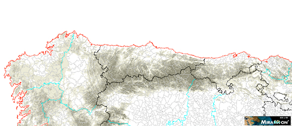
Fig. 3- Map of the climatic suitability of yew (Taxus baccata) in the NW of the Iberian Peninsula.
This approach is useful for the conservation of the species. For example, it is possible to estimate the distance that the species would have to travel from their current location to find suitable climatic conditions in the future. However, in addition to the climate, there are other conditions that explain the distribution of the species and that we must take into account. For example, in the previous case, the distances that have to be traveled to find suitable future conditions do not represent the same for the species if there is good connectivity in the territory or if a fragmented landscape predominates.
Historical legacy of human activity in the distribution of species
Obviously, this procedure - known as correlative, niche, or envelope models - has some limitations. To begin with, the data base may be biased if there are areas that have been more prospected. More importantly, the distribution of species does not depend only on climate, but other environmental variables are important, such as the type of soil for plants or the type of vegetation for many animals. The distribution of the species also depends on their dispersal capacity, that is, it will not be found in a suitable site if it has not yet been able to reach it. This illustrates the importance of the historical legacy, which is not reflected in the climatic variables. Surely the main agent of that legacy is human activity. Humans have moved species, voluntarily or involuntarily, throughout the territory over time, while eliminating others, either by overexploitation, because they were considered harmful, or simply to favor other species. Some experts say that the distribution of forest species in Europe is better explained by historical management than by any other cause. In a study that we published with Pep Serra and Trevor Keenan a few years ago, we observed that the models predicted certain values of climatic suitability for Aleppo pine in localities of the southeast of the Iberian Peninsula where other models based on the species physiology discarded its presence. The explanation is that the repopulations during the last century have forced the growth of this species in very unfavorable places. On the contrary, physiological models showed that Aleppo pine could grow well in localities of the north of the Iberian Peninsula, where it is not found, probably, because other more adapted species grow better and exclude it. Some of these limitations can be minimized using different techniques of data processing or certain calculation algorithms. However, we must be aware of these limitations and recognize that we are facing statistical projections and not real future predictions.
Climatic suitability for different populations and species in episodes of extreme drought
In spite of these problems, these techniques allow to improve the characterization of the climatic requirements of the species. For many years, this characterization has been based on some categories - for example, Mediterranean species, Eurosiberian species, etc. - that combined climate and geographical region as proposed by experienced naturalists. These categories continue to be used on a regular basis, although they will probably be replaced in the future by more or less detailed quantifications, so that, for example, we can say that a locality is climatically suitable for a species with a value determined on a scale of 0 a 1. This has the great advantage that it allows to standardize the way in which species that live in a site differently experience the same climatic conditions due to their own physiological characteristics. In a context of climate change, this is important to estimate the behavior of different species in a community. In a series of studies on Mediterranean shurblands that have experienced important die-off due to periods of drought, we have verified that the species are more vulnerable when their climatic suitability is lower in the affected location. The specific drought conditions can be incorporated into the models, and thus we can obtain climatic suitability values during the drought episode for the different species. In fact, it usually happens that these values are very low, which indicates that the plants that survive the episode do so thanks to accumulated reserves or access to microenvironments with a little more water availability. In this study we were able to observe in real time how, in plant communities, the extreme episodes of drought act as an environmental filter that favor those species most used to arid climates. This is true even in ecosystems such as the Mediterranean, already with a period of heavy water stress.
n the other hand, in other studies in which the variation of climatic suitability of the same tree species, Pinus edulis along its distribution range in the SW of North America, was compared through a drought period (Figure 4), we observed a greater vulnerability of the populations submitted to the combination of a low climatic suitability during the drought and high suitability in previous years. Therefore, even populations that live in good climatic conditions can be affected by the greater variability inherent to climate change, and specifically, by periods of extreme drought. The climate models tell us that we expect that these episodes of drought, together with torrential rains, will be more frequent and intense in the future in many regions, such as the Mediterranean. Some recent study estimates that currently half of the annual rainfall falls in 12 days on average for the entire Earth, but in the next future it will only take 6 days to reach that same percentage. The reason for the behavior of these populations of P. edulis, is that they have experienced an acclimation to good weather conditions, implementing structures or metabolic pathways that, in contrast, make them more vulnerable when resources are scarce - for example, building wide conductive vessels they optimize water flow, but that makes them more vulnerable to embolism. We can easily apply these situations to human societies, which in times of abundance generate dependence on resources whose temporary scarcity can cause great catastrophes.
-
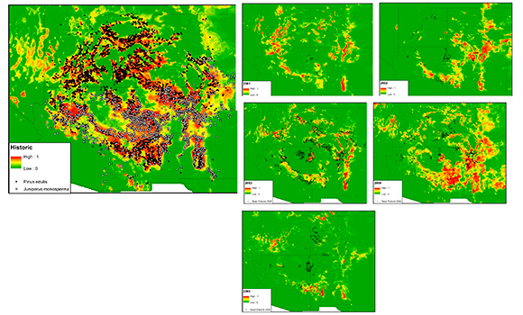
Figure 4. Climatic suitability of Pinus edulis in the SW of North America during the drought period of 2001-2005 (right) and in previous years (left).
This approach that considers the climatic suitability of the species is susceptible to be applied to different ecological processes in which the climate has a direct impact on species behavior. This is the case of forest pests, in which drought conditions make trees more vulnerable to attack by insects, such as bark-beetles, by depleting resources for defense. In turn, the attack of these insects makes trees more vulnerable to drought by reducing their photosynthetic surfaces and their reserves - this is what happens also with defoliating insects such as the processionary. In fact, pine populations in Catalonia that live in suitable climatic conditions has been observed to be particularly vulnerable to attacks of bark-beetles of the genus Ips when these localities are climatically favorable for these insects.
Spatial dimension of Ecology
Ecology has always recognized that the phenomena it studies are very dependent on the spatial environment in which they are produced. The development of cartographic techniques in combination with computing and large databases has made it possible to answer questions that seemed unapproachable a few years ago. It is well known that the advance of science benefits from fertilization between disciplines. But we must be aware of the limitations that this transfer between fields of knowledge entails, since it often implies simplifications, as when premises scarcely checked are accepted. The ability to incorporate in our analyzes multiple cases of a certain phenomenon shows the difficulty to apply generic explanations without considering the historical legacy and the spatial context. The great theories of Physics encourage us to investigate the universal principles, but that same discipline teaches us through the study of complex systems, the need to consider the spatial and temporal complexity of ecological phenomena.


