Drought is already one of the 4 most critical natural hazards in Southwest Europe
Drought and its consequences is one of the 4 most critical natural hazards in the mountain areas of Southwest Europe, together with floods, fires and soil degradation. This is one of the starting points of the third transnational seminar on strategies for the management and prevention of drought impacts on mountain forests in Southwest Europe, integrated in the SUDOE MONTCLIMA project.
The seminar brought together researchers and forest management representatives from Andorra, Spain, France and Portugal in Barcelona, at the invitation of CREAF, to share results and direct experiences. In particular, they shared the pilot case studies for improving governance and management of natural risks through transnational cooperation, joint management and risk prevention of this project led by the Observatorio Pirenaico del Cambio Climático (CTP-OPCC).
As a recurrent and extreme phenomenon, droughts are difficult to predict, with high spatial and temporal variability, in the words of Sergio Vicente-Serrano, researcher at the Instituto Pirenaico de Ecología and linked to the IPCC. The scientist attributes the greater need for water in forests in contexts of drought to the greater demand for water by the atmosphere. Therefore, if the scenarios of rising average temperatures are confirmed, it would mean significant stress for forests, especially if accompanied by an increase in the frequency and intensity of droughts.
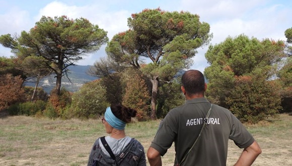
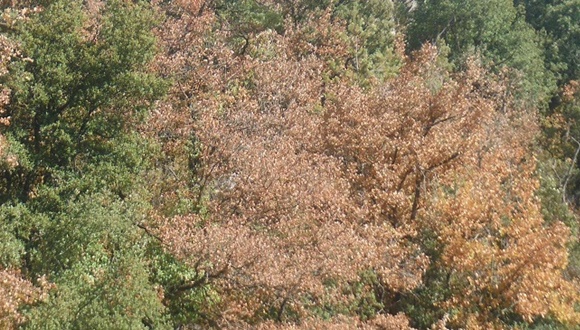
Cases of forest decline due to dry weather are increasing worldwide, especially in mountain areas. This phenomenon has affected 3.3% of Catalan forests between 2012 and 2020.
Cases of forest decline due to drought are on the increase worldwide, especially in mountain areas. According to Jordi Martínez-Vilalta, researcher at CREAF and professor at UAB, this phenomenon has affected 3.3% of Catalan forests between 2012 and 2020. All the models coincide in predicting a greater incidence of this phenomenon in the coming decades, constituting changes in the surface area, density and composition of forest masses. According to the researcher, "the impact of droughts on forest mortality is a complex process that we are not yet able to model accurately". Martínez-Vilalta also points out the difficulty of predicting catastrophic events, due to the existence of compensation mechanisms and the natural resilience of forest stands.

"All models agree in predicting an increased incidence of drought in the coming decades, constituting changes in the area, density and composition of forest stands. But the impact of droughts on forest mortality is a complex process that we are not yet able to model accurately"
JORDI MARTÍNEZ-VILALTA, researcher at CREAF & professor at UAB.
How to monitor a dry forest
From Portugal, Célia Gouveia from the Universidade de Lisboa presents the analysis of satellite images to analyse surface disturbance and plant degradation on the Iberian Peninsula. Her main conclusion is that evergreen and larger trees are generally more resilient to drought. Such indices based on satellite imagery are of great value in defining the impact of droughts on vegetation.
Forest health in France is recorded through detailed monitoring of drought-affected areas. This is the experience shared by Morgane Goudet, from the Forest Health Department of the French Ministry of Agriculture and Food. Its great value in identifying the most vulnerable areas lies in a comprehensive database on decay, pests, etc., which is cross-checked with meteorological information and future climate projections.
The monitoring and decay of forests in Catalonia carried out by the DEBOSCAT programme was presented by CREAF research technician Mireia Banqué, who explained how decay episodes are detected, their recurrence and how forests recover after an episode. The conclusions of this monitoring are crucial in order to define which areas are priorities and thus support the adaptive forest management of the territory. CREAF therefore monitors this situation together with the Agents Rurals de Catalunya.

Drought at a local scale
The sustainable forest management of pine forests in Valladolid was the focus of the talk by Alfonso González Romero, from the Junta de Castilla y León. The Pinus pinaster forest stands are the most affected by decay, according to his intervention, and are attributed to a combination of drought, human overexploitation of water resources and sandy soils with low water retention capacity. Castilla y León is working on a mechanism for recovery, and points to the need to implement flexible management methods to limit decline.
As for French public forests, the main objective of the Office National des Forêts is to ensure that the multifunctionality of forests is maintained, to increase their resilience to climate change, and to maintain the biodiversity of species, according to Thierry Sardin.
The SUDOE MONTCLIMA pilot experience was presented by Diana Pascual, from CREAF, to talk about adaptive forest management in a holm oak forest in the Montnegre-Corredor massif (Barcelona), as the key to boosting the resilience of mid-mountain forests in the face of drought and fire risk. CREAF researcher Eduard Pla is also involved in this work. The direct experience in Andorra was presented by Marc Font, from Andorra Recerca + Innovació, who discussed the impact of future droughts on the resilience of forests, and the effects this could have on their protective role in the face of gravitational risks.

Increasing resilience
One of the relevant aspects of the MONTCLIMA project is that it facilitates knowledge of the evolution of the different forest species due to climate change. Thanks to the CLIMESSENCES tool, the Office National des Forêts can carry out this monitoring, based on the scenarios established by the IPCC to obtain future distribution situations. The model generates 2 types of maps presented by Xavier Bartet: of similar climates and of climatic compatibility.
The forest management model of the LIFE RESILIENT FOREST project and the silvicultural treatments to support management were presented by María González Sanchís, from the Universitat Politècnica de València. This model aims to promote sustainable forest management, and allows the inclusion of up to 5 objectives weighted according to the user's interest.
Finally, the study of the changes in the main forests of Portugal has made it possible to pool the combination of the bioclimatic indices observed. This is a study of the University of Trás-os-Montes y Alto Douro presented by João A. Santos.
A tool to reduce uncertainty
The Geovisor open-source, geolocalised map viewer allows real-time consultation of indicators of active fires, burnt areas and accumulated rainfall.
The Geovisor open-source, geolocalised map viewer allows real-time consultation of indicators of active fires, burnt areas and accumulated rainfall. This tool also provides additional information on MONTCLIMA's pilot experiences: "Monitoring is one of the most powerful tools we have to reduce uncertainties. It is undoubtedly our best asset to avoid surprises," says Jordi Martínez-Vilalta.
One of the tools for the MONTCLIMA project to strengthen the management and prevention capacity in the mountain territories of southwest Europe in the face of natural hazards is the creation of a transnational strategic framework, capitalising on previous successful projects. This initiative is in line with the UN Sendai Framework for Disaster Risk Reduction and the Paris Agreement on climate change.


