The war in Syria has wiped out 19% of the country's forests, equivalent to the entire metropolitan area of Barcelona


The war that has been raging in Syria since 2011 has wiped out 19.3% of the country's forest cover in 9 years, which represents 63,700 hectares of its territory, an area equivalent to practically the entire metropolitan area of Barcelona. The loss of forest mass suffered by the Middle Eastern country during the war has basically two origins: the constant escalation of artillery bombardment and the effect of the large number of internally displaced persons, estimated at 6 million. The consequences are, on the one hand, that explosions and attacks cause forest fires that are difficult to extinguish in a war context and, on the other hand, that the huge number of displaced people depend on cutting down trees to make fires for heating and cooking, given the difficulty of accessing other sources of energy. In addition, the situation favours illegal trade linked to timber as a means of subsistence.
The proximity of forested areas to roads, refugee camps and urban settlements has been one of the key drivers of deforestation. These are the main conclusions of the article War and Deforestation: Using Remote Sensing and Machine Learning to Identify the War-Induced Deforestation in Syria 2010–2019, first authored by CREAF pre-doctoral researcher Angham Daiyoub, of Syrian origin. Researcher Pere Gelabert (University of Lleida) and researchers Sandra Saura-Mas (CREAF and Universitat Autònoma de Barcelona) and Cristina Vega-Garcia (University of Lleida and CTFC) have also participated.
To carry out this study, the research team used Landsat and PALSAR images with 25 m of definition that made it possible to differentiate between forested and non-forested areas. Deforestation was detected using machine learning techniques with models from previous years and annual mapping of these areas. In Syria, where field methods are difficult to apply due to war conditions, remote sensing using satellite imagery is a suitable tool to analyse the impact of conflict on the landscape.
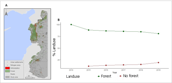
Thus, data analysis reveals a sustained loss of forest cover, mostly concentrated in the coastal-mountain range in the northeast and around Damascus, the capital in the south of the country, with long-term environmental and humanitarian consequences. The highest rate of deforestation was observed between 2010 and 2015, during which the total forest cover fell by 11.5% (or 37.9 thousand hectares). The period 2015-2018 also saw a gradual but steady decline, representing a cumulative reduction in forest area of 7.8%.
In contrast, before the outbreak of the war, the country recorded positive annual rates of forest growth, according to the Syrian Monitoring of Agricultural Resources. FAO, the UN's Food and Agriculture Organisation, reports an increase of 119,000 hectares of forest cover in the country in the decade before the war, attributed mainly to government-driven forest restoration campaigns.

"Armed conflicts and wars are key drivers of human-induced landscape change mainly due to forest destruction, but also due to pollution and oil spills".
ANGHAM DAIYOUB, forestry engineer and doctoral researcher at CREAF.
"We call on governments to enforce strict laws and regulations to protect forests and combat illegal logging activities". It is critical to preserve and restore forests, promote environmental sustainability and ensure the well-being of both displaced populations and local communities," he said. In Syria, as Daiyoub recalls, more than 13 million people needed assistance and more than 5 million people migrated.
Desforestation and war
The scientific work studies in depth the relationship between deforestation and factors linked to war and weapons, such as explosions or refugee camps, since at the outbreak of the war in Syria around 1.4 million people fled to the coast, where 90% of the country's forests are located. In this sense, the difficult survival in non-urban areas and the absence of guards and suppression of environmental preservation laws generate a high dependence on forests in these situations. Thus, there are direct causes of this deforestation, where trees are cut down to obtain wood as an additional source of income and as fuel, in the form of firewood for heating and cooking. In fact, the results showed that most of the deforested areas were very close to roads, about 0.04 and 0.39 km from these roads, and that the probability of deforestation was higher in areas located closer to refugee camps. In contrast, most of the deforested areas were found to be further away from urban areas, between 12.6 and 30 Km. This is because roads facilitate connectivity and access to forest resources for sale in local timber markets and urban settlements, and in the case of refugee camps, wood is a key element for heating and cooking.
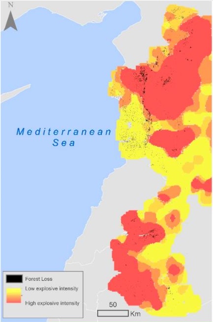
The study also identifies indirect causes of deforestation, such as fires and explosions. According to the results, forest fires were responsible for 23.4% of the loss of forest cover, mainly in the northwest. More than 50% of deforestation occurred in areas affected by high explosives. Bombing and charcoal production also caused forest fires and deforestation in the study area. During the conflict, the forest can be an additional source of income for local communities, at a time of absence of guards and suppression of enforcement of environmental preservation laws. In addition, the difficult survival of non-urban mountain dwellers, displaced people from urban centres and mobilised troops generates a high dependency on the forests as a source of fuel and for hunting wild animals for food.


